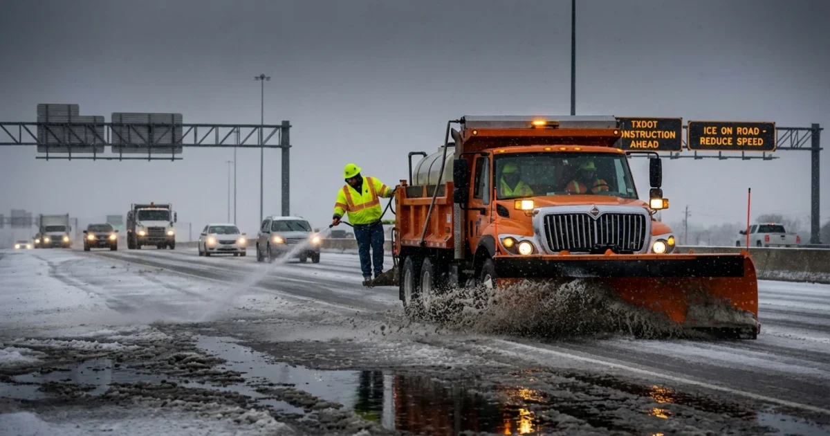
Breaking: Ice is turning Houston roads into a trap this morning. Freezing rain and sleet are glazing highways from the Bay Area to The Woodlands. Overpasses are slick. Elevated ramps are shutting down in waves. I am tracking TXDOT’s live map and road crews confirm conditions are changing minute by minute. If you do not need to drive, do not.
Ice grips Southeast Texas right now
A shallow layer of Arctic air has slipped into the metro. Warm Gulf moisture is riding over the cold surface. That is the recipe for freezing rain, with pockets of sleet and even brief snow bursts on the north side. The worst spots are the places that cool fastest. Bridges, flyovers, and shaded stretches are first to freeze, and last to thaw.
TXDOT has pretreated major corridors with brine. That helps, but it does not erase black ice when fresh freezing rain falls. Crews are spreading more material and rotating plows on key routes. Expect rolling closures on elevated connectors, on parts of I-10, I-45, I-69, Beltway 8, and SH 99. Traffic is slow, and it should be.

Black ice looks like wet pavement. Assume every bridge deck is slick, even if it looks clear.
The science behind the slick
Freezing rain forms when snow melts into rain higher up, then the droplets hit subfreezing roads. They freeze on contact and build a thin glaze. Sleet happens when those droplets refreeze into small pellets before hitting the ground. Both reduce tire grip fast.
This setup is classic for the Gulf Coast. A strong cold front brings dense air at the surface. Above it, winds pull in moisture from the Gulf. Today, that layer is just warm enough to melt flakes aloft. Then the rain falls into air near 30 to 32 degrees at the ground. The result is glaze ice, not fluffy snow.
Climate change adds a twist. Warmer oceans feed storms with more moisture. At the same time, the jet stream can wobble, which can push Arctic air farther south. That mix means rare but potent icing events can be more disruptive. More water in the air, plus sharp cold near the ground, equals heavier icing when it happens.
Use TXDOT’s DriveTexas to make smart moves
TXDOT’s DriveTexas.org map is the most direct look at what is closed, iced, or backed up. I am watching it live. You can, too, before you choose a route.
- Open DriveTexas.org, then zoom to Houston and Southeast Texas.
- Turn on layers for closures, construction, and hazardous conditions.
- Tap icons for details on crashes, icing, and lane status.
- Check camera icons where available to see the road surface.
- Refresh often. Conditions can change in five minutes when freezing rain intensifies.
If your route crosses a bridge, look for alternate ground-level roads on the map. Elevation is the enemy today.
Safety first, and smarter choices
Travel only if you must. If you do go, treat the road like it is covered in oil. Ice offers almost no warning and little second chance.
- Slow down, far below the posted limit
- Increase following distance to a city block in length
- Do not slam brakes, ease off and steer gently
- Avoid cruise control, keep both hands steady
- Skip elevated lanes and tollway ramps when possible
Idling in a cold gridlock burns fuel and risk, and it exposes crews to danger. Staying home is a climate smart choice, too. It trims emissions and gives TXDOT the room to work faster and safer.
Salt and brine help today, but their runoff can stress streams and soil. Crews use targeted treatments to limit harm. Your best tool is avoidance, not more salt in neighborhoods.
What to expect through tonight
Temperatures lag behind the sky. Even when the radar quiets, ice can persist because road decks stay colder than the air. Expect only slow melting during brief midday lulls. Any wet pavement can refreeze late afternoon and evening as another push of cold air settles in. I am watching for a second wave of slick spots after sunset, especially on north and west sides of the metro.
Power demand is up as heaters run. That matters for safety and for the grid. Keep thermostats moderate, close curtains, and charge devices while you have stable power. If you lose heat, do not run generators indoors. Carbon monoxide has no smell.
Bottom line
This is a fast moving, high impact ice event for Southeast Texas. The safest plan is to avoid nonessential travel until temperatures climb above freezing for several hours. Use DriveTexas.org before any trip, and be ready to turn around if conditions worsen. I will keep tracking TXDOT road conditions and the next surge of cold, and I will update as the map and the sky change. Stay patient, stay warm, and give crews the space to win back the roads.


