BREAKING: Winter weather warnings are up across New York as a fast moving system targets the state on Thursday. Snow, wind, and bitter cold will sweep in from west to east. Upstate communities should brace for the heaviest totals. The New York City region sits near a tricky rain and snow line. Small shifts in the storm path could flip the forecast near the coast. Commuters need a plan now.

Who gets snow and who gets a mix
The North Country and Tug Hill are in line for the most snow. Cold air is locked in there. Expect several inches, with higher drifts where winds funnel along ridges. The Adirondacks and western slopes will also stack up fast. Central New York, including Syracuse and the Finger Lakes, looks snowy for most of the day. Travel will be slow on secondary roads.
Rochester to Buffalo starts with steady snow, then bands will pulse as winds pick up. Once the main system moves out, lake effect will kick in. The warm lakes are still open in spots. That fuels extra squalls Thursday night and Friday in the usual belts south and east of Lake Erie and Lake Ontario.
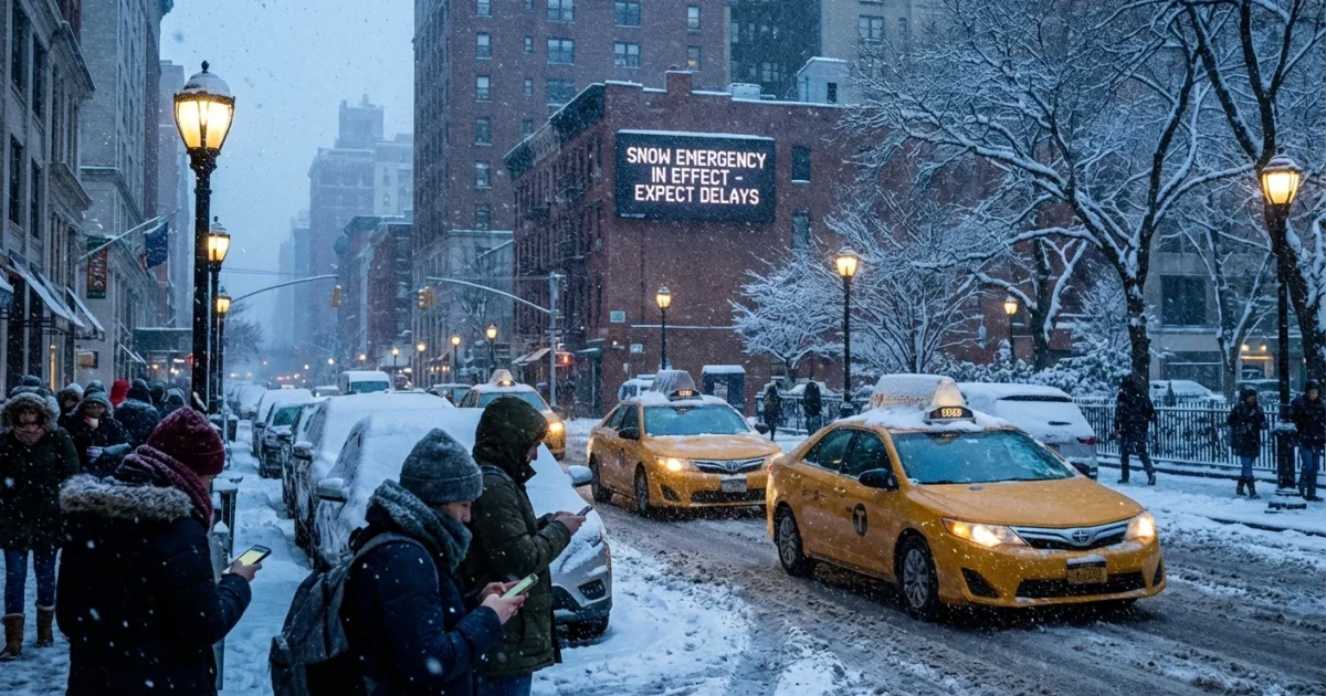
The Capital Region and Mohawk Valley should see a plowable snow by Thursday afternoon. It may mix for a time along the Hudson Valley, especially near Poughkeepsie and south. South of there, the New York City metro is a tougher call. A wintry mix is likely from the city to western Long Island. Lighter snow totals there, but slick conditions can be just as disruptive. If the coastal low hugs closer, colder air could win for a few hours and bring a quick burst of snow even to the five boroughs.
Timing the storm on Thursday
Pre-dawn to 8 a.m.
Snow reaches far western New York before sunrise. Roads turn slick first around Jamestown, Buffalo, and Niagara County. Flurries expand toward Rochester and the Southern Tier near the morning commute.
8 a.m. to noon
Snow spreads into Syracuse, Ithaca, and the Mohawk Valley. The morning commute degrades fast. Plows will make progress, but rates could top an inch per hour in the heaviest bands. Albany sees steady snow by late morning. New York City and Long Island pick up a light mix or wet snow on the north shore.
Noon to 4 p.m.
The core of the storm moves over central and eastern New York. Expect low visibility and gusty winds. Hudson Valley towns ride the line between snow and sleet. The city sees periods of sleet and rain with brief wet snow at times, especially north and west of the city.
4 p.m. to late evening
The evening commute will be rough across the Thruway corridor. Snow continues in Albany and the Catskills, then tapers later at night. The front edge exits eastern counties after sunset. West of Rochester, the broader snow ends, but lake effect ramps up.

Wind, cold, and road impacts
Winds will gust 25 to 35 miles per hour, higher on exposed hills and along the lakes. That means blowing and drifting snow, even where totals are moderate. Expect sudden drops in visibility on open stretches. Wind chills fall well below freezing everywhere by late day. Inland cold spots dip to single digits by Friday morning. I am also watching for spotty power issues where heavy, wet snow coats branches near the rain and snow line.
Give yourself extra time. Use low beams in snow and sleet. Do not crowd plows or emergency crews.
Why this storm looks the way it does
This setup is classic winter clash. Arctic air is pouring in from Canada. Moisture rides north from the Atlantic as a coastal low deepens. Where that low tracks controls the rain and snow line near the city. A shift of 25 to 50 miles can change who gets heavy snow versus sleet. Warmer Great Lakes delay freeze up, so lake effect can run hotter after system snow. That is a growing trend in a warming climate. Winters are shorter on average, yet bursts of heavy snow still happen when cold air snaps into place. Near the coast, warmer seas favor more mixed precipitation and heavier, wetter snow. That adds risk for trees, wires, and commutes.
Smart prep for a winter commute
Small choices today can prevent big problems tomorrow. Top off fuel and charge phones. Check wipers, tires, and washer fluid. Pack a simple kit with warm layers, snacks, and a flashlight. Shift meetings if you can. Use transit where reliable.
- Keep a scraper, shovel, and sand or kitty litter in the car
- Wear traction friendly shoes for icy platforms and sidewalks
- Stagger travel to avoid the peak snow rates
- If you work outdoors, rotate breaks to warm up
Plan two routes, a main road option and a back up. Main routes are plowed first and drain better.
The bottom line
Snow, wind, and cold will hit New York on Thursday, then lake effect lingers in the west and north. Upstate will see the greatest snow, while the city rides a thin line between mix and wet snow. Stay flexible, watch for updated advisories, and be ready to pivot. I will keep tracking the storm path and the rain and snow line through the day. Safety first, then speed. Winter is back, and it means business ❄️.


