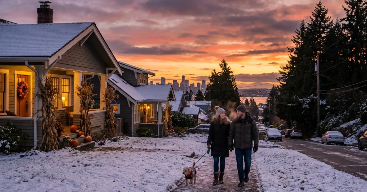
Cold air has locked in over Seattle, Washington, and it is not letting go tonight. I am tracking a cold weather advisory that now runs into Sunday morning across western Washington. Expect freezing nights, biting wind chills, and a slick start to early commutes. This is a sharp, dry chill, and it feels even colder along the water and on higher hills.
Arctic air grips the city
Colder air filtered in from the north today. Temperatures dropped fast after sunset. Many neighborhoods will dip below 32 degrees overnight. Wind will make it feel like the teens in exposed spots near the Sound and in the north end. Frost forms quickly in this pattern. Side streets, bridges, and shaded sidewalks are already icy.
Tonight also brings a quiet seasonal milestone. West Seattle sees the last sunset in the 4 pm hour until late fall. Light will stretch a bit longer next week, but the air will still feel like winter. The bottom line, the region is locked in a cold snap, and the hazards are real.
Black ice will form overnight on bridges, hills, and shaded sidewalks. Slow down and test footing.
What to expect through Sunday
The advisory covers the entire metro and much of the lowlands. Lows fall to the upper 20s in the city, colder in the outlying valleys. Gusts along the water add to the chill. Most places stay dry, but pockets of freezing fog could glaze roads before dawn. A few flurries are possible near the Cascade foothills and in classic convergence zones, mainly north of the ship canal.
Saturday’s sunshine will not feel warm. Highs reach the upper 30s to low 40s, which slows melting. Wet spots refreeze after dark. Sunday morning starts crisp again, then a slow break as the air mass begins to ease. Another cold night is possible for the north Sound and higher neighborhoods like Queen Anne and Capitol Hill.
Commuters should plan for extra time. Buses and light rail can run smoothly in dry cold, but platforms and stairs may be slick. Cyclists and walkers should watch for black ice at driveway aprons and crosswalk lips. Drivers, keep speeds down through shaded corridors like Lake City Way and Admiral, and over elevated spans.
The climate signal behind the chill
Cold snaps still happen in a warming climate, and this is one of them. What we are experiencing is a classic winter setup for the Pacific Northwest. High pressure offshore and a northerly flow opened the door to Arctic air. The jet stream dipped south, then parked. That allows cold to pool over the lowlands for a few nights.
Here is the larger story. Winters in our region are trending milder on average. The first and last freezes of the season are shifting. We are seeing fewer cold days overall, but the cold that does arrive can still hit hard. When the air is this dry, energy demand spikes, pipes are stressed, and vulnerable neighbors face real risk. Managing these swings is part of our climate reality.
Sustainability matters in moments like this. Small choices scale up when a whole city makes them. Efficient heating, safe travel habits, and smart water use all cut strain on the grid and on the community.
How to stay safe and sustainable
Bundle up in layers, not just thicker clothing. Cover hands, ears, and face. If you rely on space heaters, give them three feet of clearance. Never use grills or ovens for heat. Keep pets inside, and bring plants off balconies.
Layer up, cover hands and ears, and let faucets trickle to protect pipes. Open under-sink cabinets to keep warm air moving.
If you must drive before sunrise, treat every shaded patch like ice. Gentle steering and slow braking help you keep control. Consider transit once walkways are treated, since cold air does not slow trains and buses as much as snow does. If you are heading out early, pack a simple cold kit:
- Warm gloves and hat
- Ice scraper and traction sand
- Phone charger and flashlight
- Water and a small snack
Warming centers are opening across Seattle and nearby counties. Libraries, community centers, and some shelters extend hours in events like this. Check your city or county alert pages for the latest locations and times. Snohomish County is urging extra layers in the morning. South King County valleys will feel colder than the thermometer reads.
Warming centers are open or on standby. Call your city’s information line, or check county alerts for exact sites and hours.
The bottom line
Seattle is in a clean, hard freeze, and the risk lasts into Sunday morning. Expect frosty mornings, icy patches, and wind chills that bite. The cold will ease slowly, not all at once. Take it steady, look out for neighbors, and use heat wisely. Winter is not leaving, but our days are getting longer. Stay warm, stay safe, and keep the city moving. ❄️


