Breaking: King tides and a powerful Pacific storm are flooding parts of the San Francisco Bay Area right now. Water is pushing over shorelines, closing roads, and stranding drivers. In Larkspur, residents are reporting the highest high water they can remember. The timing is brutal. The tide is at its peak as heavy rain and strong onshore winds push even more water into the Bay. 🌊
What’s happening right now
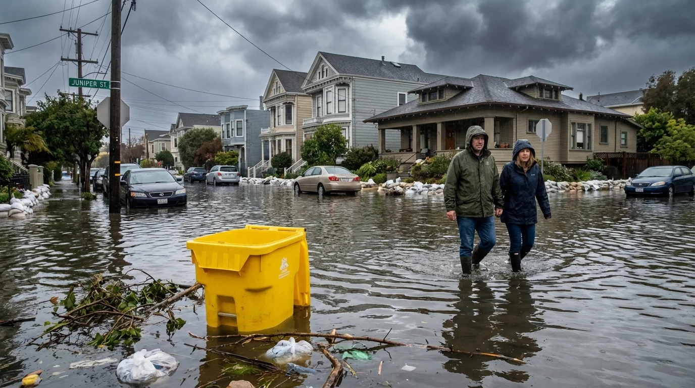
Low lying neighborhoods across Marin and the Peninsula are taking on water. Several bayside roads are closed. So are underpasses that fill fast when tides and runoff meet. Parking lots along the shoreline are swamped. Creeks are backing up where they meet the Bay. Drainage systems cannot keep up.
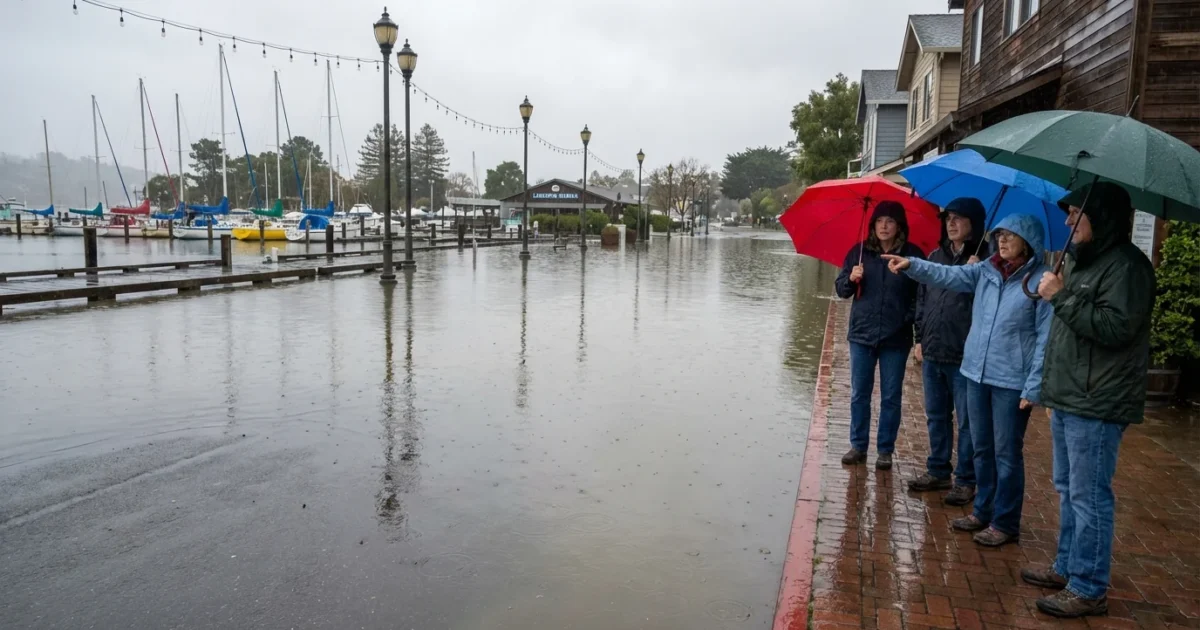
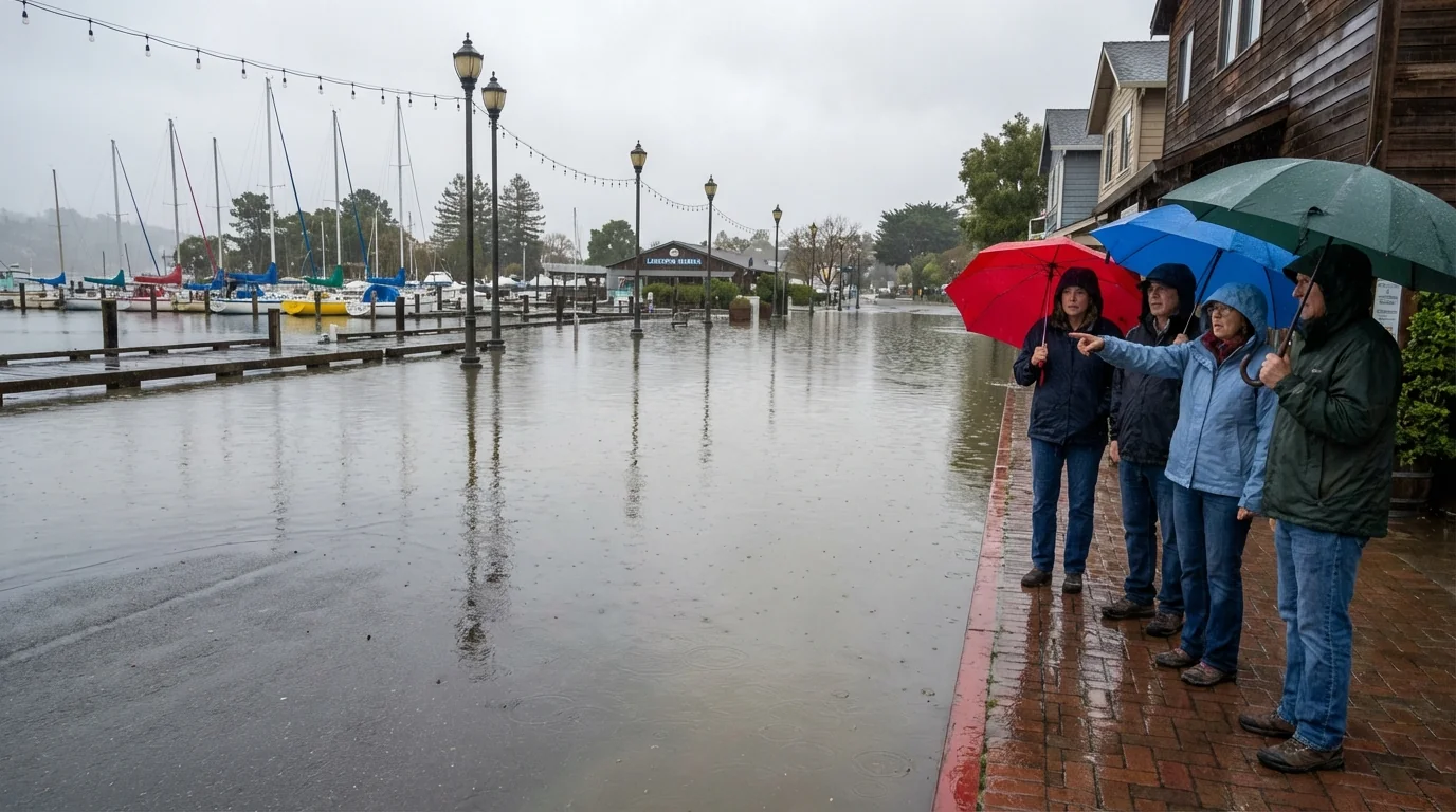
In Larkspur, water is overtopping docks and paths. Tidal flooding is spilling into streets near marinas. Similar scenes are unfolding from Sausalito to Alameda. The Embarcadero is seeing splashover at high spots. On the Peninsula, pockets of Foster City and Redwood Shores are dealing with curb high water. These are the places closest to the Bay. When king tides hit, they feel it first.
The storm itself is potent. Bands of heavy rain are moving through, with gusty south winds over the water. That wind pushes the Bay’s surface north and east. The storm’s low pressure also allows water levels to sit a little higher than normal. Add runoff from hills and creeks, and the system gets overwhelmed.
Never drive through flooded roads. Water hides hazards and can move fast. Turn around, do not risk it.
Why this flood is so severe
This is a classic stack of forces. Extreme tide. Strong onshore wind. Heavy rain. All arriving together.
How king tides and storms stack
King tides are the highest highs of the year. They occur when the Moon, Earth, and Sun line up just right. On their own, they can flood the usual trouble spots. Today, they are meeting a storm surge and heavy rain. The Bay’s shape then amplifies the effect. Narrow channels and shallow edges force water higher into creeks, sloughs, and low streets.
San Francisco’s long running tide gauge shows sea level has risen close to 8 inches since the late 1800s. That higher baseline means every storm tide starts from a higher point. What used to stay in the marsh now finds the roadway. What used to be a splashover becomes a street flood.
King tides are previews. The scenes we see today will look normal later this century if seas keep rising.
Warm air also holds more moisture. That boosts the rain in modern Pacific storms. Many of our biggest winter rains come from atmospheric rivers. When they arrive on top of a king tide, the risk jumps.
The next several hours
Expect water levels to spike around each high tide. Another high tide cycle arrives this evening. Where streets are already wet, new bands of rain can push them back under. Creeks that drop at low tide may not drain as well if the Bay stays high. Ferries and shoreline transit can be delayed when docks sit at odd angles.
- Do not park in low lots near the Bay or creeks
- Keep clear of seawalls and jetties during peak tide
- Secure trash bins and yard items that can float away
- Check sump pumps and basement drains
Know your local high tide time. A 30 minute window can decide whether a block floods or stays dry.
What this means for Bay Area resilience
Today’s flood is more than a one day mess. It is a stress test for our shoreline. Stormwater pipes often drain by gravity into the Bay. When the Bay is higher than the outfall, water backs up into streets. Tide gates help, but many are old or undersized. Seawalls can stop waves, but they reflect energy and fail when overtopped. Roads built at old elevations sit in the new splash zone.
Solutions are clear, and they work best in layers. Raise key roads and protect lifeline corridors. Restore tidal marshes that absorb wave energy and store floodwater. Build living shorelines using reefs and plants that grow with sea level. Upgrade pump stations and tide gates so stormwater still moves out at high tide. In some places, plan to step back from the most exposed edges. Every year we wait, the baseline gets a little higher.
Climate context and the path forward
Greenhouse gas pollution is warming the ocean and melting land ice. Sea level rise is the long fuse that makes today’s king tide look like tomorrow’s average. Cutting emissions slows the rise later in the century. It does not lower today’s tide. That is why adaptation matters now. Local projects, from marsh restoration to higher seawalls, are not luxuries. They are the cost of staying put.
We are witnessing a live collision between weather and water. The storm will pass. The king tide will ebb. But the pattern is set. When very high tides meet powerful rain and wind, the Bay Area floods. Planning for that new normal is no longer optional. It is our job if we want to keep roads open, homes dry, and the shoreline alive.


