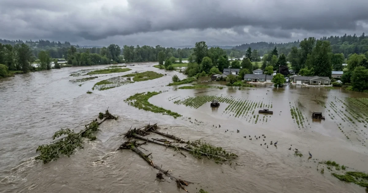
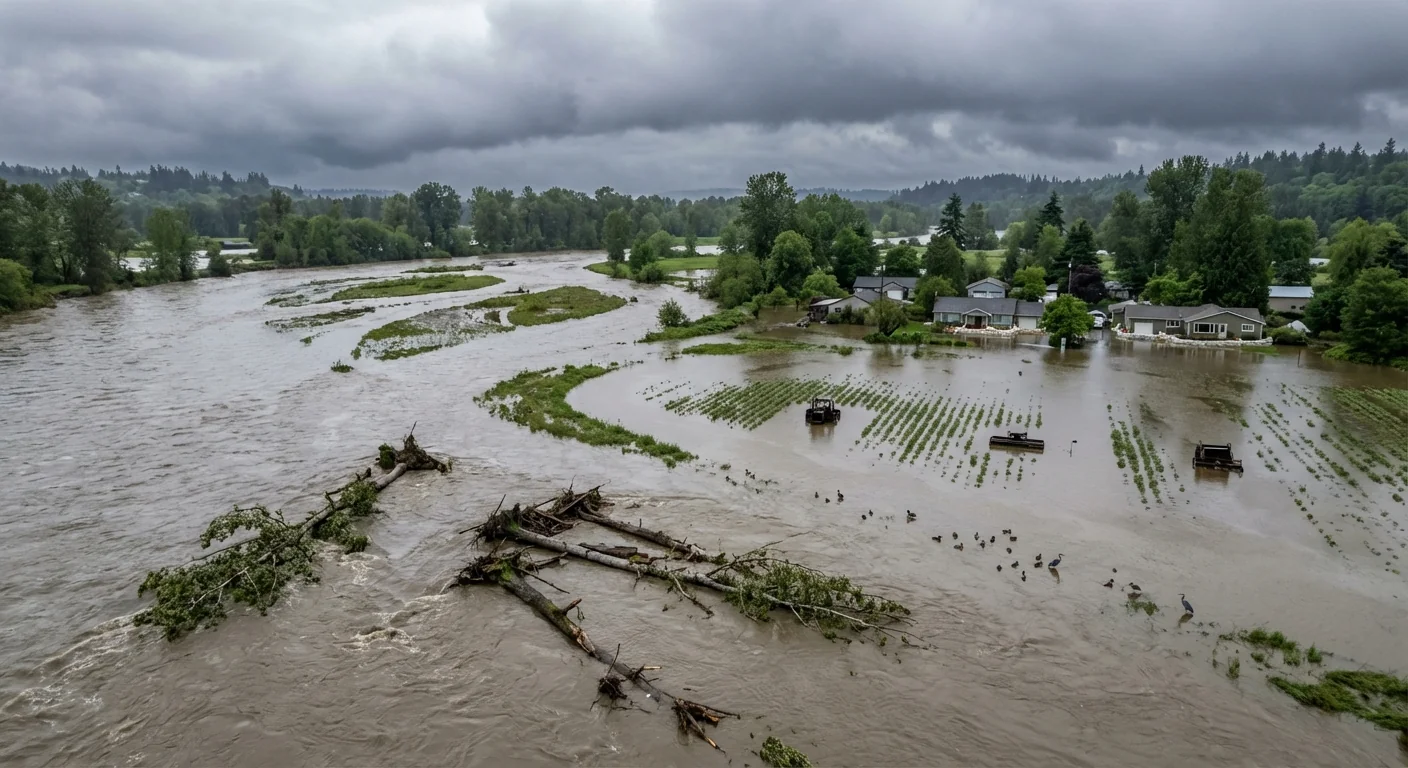
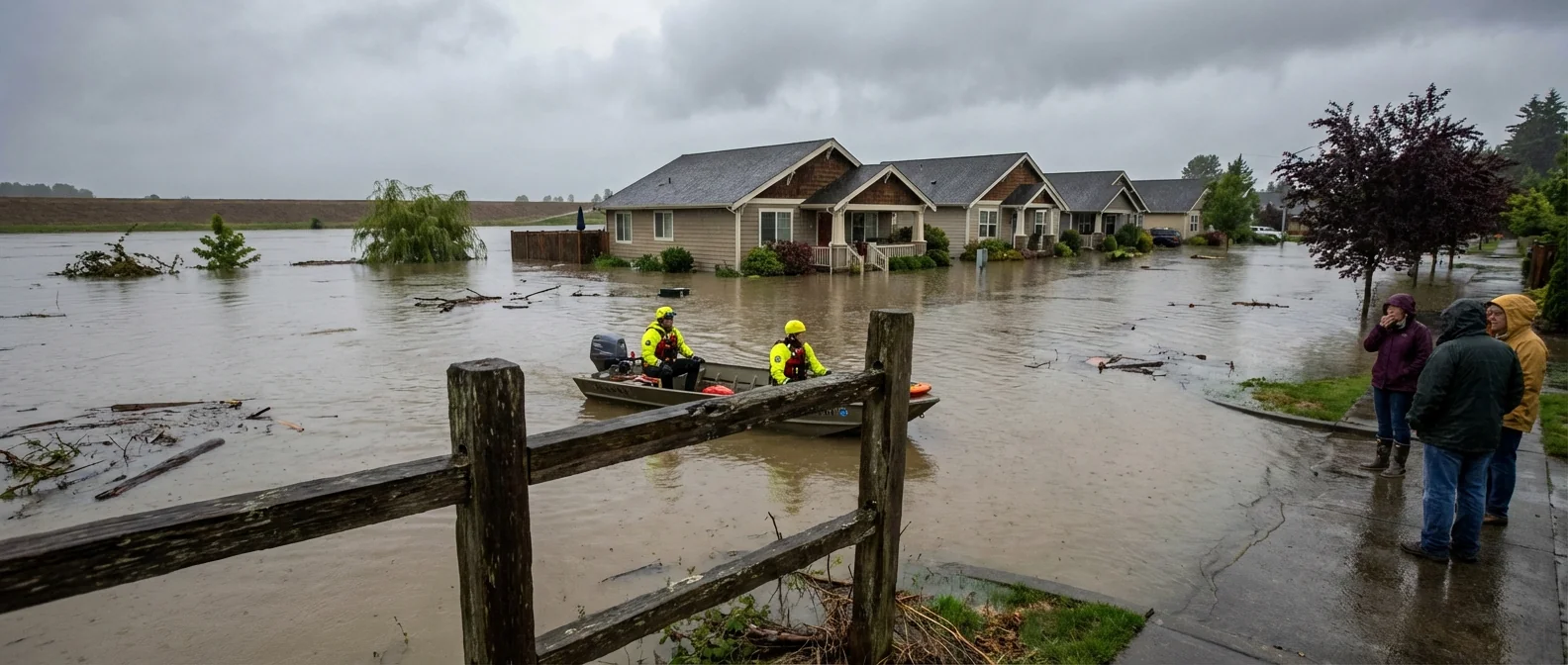
Breaking: A Green River levee has failed in southern King County, near Seattle. Water is moving fast. The break turned a high river into a dangerous flood threat within minutes. I am watching crews pile rock and sand as the river pushes through the gap. Sirens and loudhailers echo across low ground. This is a life and safety emergency.
Levee breach and immediate risk
The breach sits along a vulnerable reach of the Green River. Downstream neighborhoods, farms, and business parks face rising water. Roads that dip near the river are already slick and unsafe. The threat is highest for basements, ground floor units, and older drainage systems. Officials have warned that flash flooding is possible if the cut widens.
If you live in a low area near the Green River, be ready to leave now. Move to higher ground, avoid floodwater, and follow local alerts.
Floods move faster than they look. They carry debris that can block culverts and push water into new places. Nightfall will make hazards harder to see. Treat every flooded roadway as closed.
On the ground: the fight to hold the line
I am seeing excavators place rock into the breach while crews stack sandbags behind them. The river is chocolate brown and loaded with sticks and root balls. Spotters are tracking boils in the fields, a sign of water tunneling under the levee. Utility crews are marking gas and power lines. Helicopters are not needed yet, but standby teams are ready.
Drone views confirm the repair push is steady. Water is spilling into side channels and old oxbows, which buys a little time but spreads the footprint. The river level is still volatile. Any new burst of rain could erase gains.
How the weather set this up
The soil was saturated after days of steady rain. Then a warm storm added more water fast. Snow at mid elevations melted into the system. This classic rain on snow setup is a known flood trigger in our region. The Green River responded with a sharp, quick rise.
A warmer climate is increasing the odds of this kind of event. Warmer air holds more moisture, so storms wring out heavier rain. Freeze lines climb upslope, so more watershed area shifts from snow to rain. That means more runoff in the moment, and less natural storage. Levees that were sized for past storms face bigger loads now.
The infrastructure gap
Many levees along legacy rivers were built decades ago. They can settle, crack, or get undercut by high flows. Sediment from upstream storms raises the riverbed, which reduces room for water. Development has squeezed floodplains, which adds pressure to the levee walls.
Short term, emergency rock, pumps, and sandbags can hold back water. Long term, the region needs layered defenses that match the climate we have now. Setback levees give the river space to spread and slow. Restored wetlands store peak flows and filter water. Buyouts remove the most at risk properties. Smart sensors and sirens cut warning times from minutes to seconds.
- Near term fixes, raise and armor weak levee segments, clear blocked culverts, and expand pump capacity.
- Long term moves, reconnect floodplains, build setback levees, restore wetlands, and strengthen building codes.
What residents should do right now
Assume any standing water is contaminated. It can hide potholes, downed wires, and sharp debris. Keep kids and pets away from the river edge.
Turn around, do not drive through water. Just 12 inches can float a small car. Two feet can sweep away trucks.
If you are in a flood watch zone, prepare to move. Keep your phone charged and your gas tank above half. Pack medicines, documents, food, and warm layers. Move valuables and chemicals off the floor. Unplug devices on the ground level. If told to evacuate, go. You can replace things. You cannot replace a life.
Conclusion: The river is not waiting. The levee breach in southern King County is a blunt warning from a warmer, wetter reality. Crews are fighting hour by hour to hold the line. Communities downstream must act now, then demand durable solutions once waters fall. Give the river room, rebuild smarter, and treat today as the baseline, not the peak.


