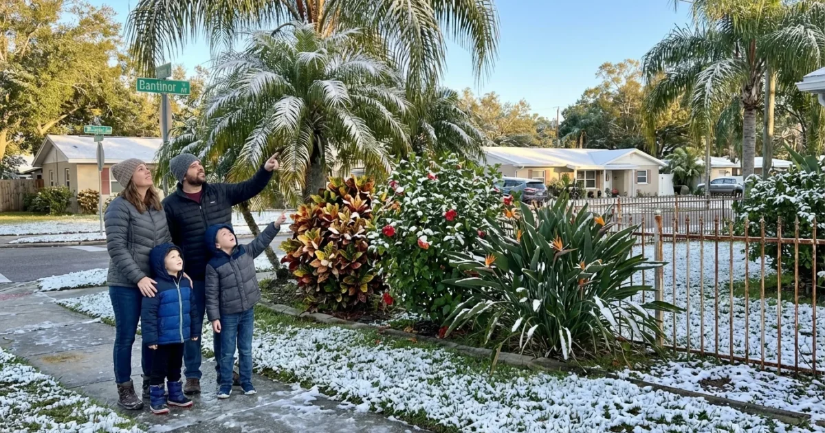
Tampa could see flakes. Yes, snow. A fierce Arctic blast is pressing into Florida right now, and Tampa Bay is on the edge of wintry weather. The air is cold enough in the lowest few thousand feet. If a band of moisture lines up, brief flurries or a rain and sleet mix may appear over the city.
What I am seeing over Tampa Bay
Cold air is spilling south across Central Florida this evening. Temperatures in the metro are falling quickly through the 30s. Wind chills are colder. Skies are mainly cloudy at times, with small breaks. A few weak bands over the Gulf are trying to move inland. If they hold together, frozen bits can survive the trip to the coast.
Accumulation is not expected. Ground temperatures are too warm. Any flakes that reach Tampa will be light and short lived. The bigger story is the freeze itself, and the wind. That is the real hazard for most neighborhoods.
Freeze and wind chills can be dangerous for people without shelter, pets, and fragile plants. Act now to protect them.
How snow becomes possible in Tampa
This setup is classic for rare Florida flurries. A strong north wind is pulling Arctic air straight down the peninsula. At the surface, readings are near freezing. Several thousand feet up, the air is well below freezing. That vertical cold layer lets raindrops freeze into sleet or form tiny snow crystals.
We also need moisture. The Gulf is the source. Shallow showers often form along the coast at night when cold air crosses warmer water. If those showers pass over Tampa, and the cold layer aloft is deep enough, a quick burst of flakes can mix in. If the showers weaken, we get only drizzle.
The jet stream is driving this southward plunge. It has dipped into the eastern United States, letting polar air escape the high latitudes. These sharp swings are part of natural weather patterns. In a warming climate, winter is milder on average, yet big cold snaps still occur. Scientists are studying how a warming Arctic may influence these jet stream bends. For Tampa tonight, that bend is the reason snow is even on the table.
Safety first during the freeze
Do not fixate on accumulation. Focus on the cold. Pipes in exposed spots can freeze. Space heaters can spark fires if misused. People who work outside face a risk from wind chills. In northern and inland counties, a few icy patches may form late tonight, mainly on bridges. In Tampa Bay, roads should stay wet, not icy, but overpasses can cool fast.
- Bring pets indoors, cover tender plants, and insulate outdoor pipes.
- Let faucets drip in the coldest rooms and open cabinet doors.
- Use space heaters on a flat, clear surface, and keep them three feet from anything that can burn.
- Check on neighbors who might need help with heat.
Layer up, limit time in the wind, and keep a backup heat plan if the power blinks. Charge phones before bedtime.

What I am watching next
- The timing of coastal showers as the coldest air arrives.
- Any radar echoes that hold together inland over Pinellas and Hillsborough.
- Temperatures at the surface and just above the ground before sunrise.
If a narrow band sets up over the bay, a few neighborhoods could see flakes for a few minutes. If the moisture misses, we stay dry and cold.
How rare is Florida snow, and what it means
Snow in Tampa is exceptional. Historic flakes have been recorded only a handful of times. Most winters pass with no chance at all. Even tonight, the city sits on a knife edge between cold, clear air and thin, weak showers. That is why any mention of snow here carries weight. It reminds us how powerful the atmosphere can be, even in a subtropical city.
Florida’s long term trend is warming, including warmer winter nights. That reduces the number of freeze days over decades. Yet extremes are still possible when the jet stream opens the door. The key for communities is resilience. Better home insulation saves energy and protects pipes. Native landscaping handles temperature swings with less water. Smarter heating and grid planning keep people safe during rare cold snaps.
Tonight is about preparation, not panic. Expect a hard chill, a biting wind, and a tiny chance at a brief wintry surprise.
Bottom line
Tampa is on flurry watch, with freezing air in place and just enough moisture nearby. Any snow would be light and fleeting, with no meaningful accumulation. The main risk is the cold itself. Protect people, pets, plants, and pipes. I will track the coastal bands through the night and update if a wintry burst targets the bay. Stay warm, Tampa.


