A dangerous winter storm is exploding in strength right now. I am tracking rapid deepening at the center of a sprawling low. Blizzard conditions will sweep the Midwest tonight, then race for the Northeast by tomorrow. Holiday travel is in the crosshairs. Tornado damage has already been reported in parts of the Midwest as the southern side of this same system tapped into unstable air. Now the cold side is surging, and the wind is rising. ❄️
What is happening now
This is a classic bomb cyclone, a mid latitude storm that intensifies very fast. The barometric pressure is dropping at a pace that can hit 24 millibars in 24 hours. That pressure fall tightens the wind field. Strong winds pull in moisture, then wring it out as heavy snow and icy mix.
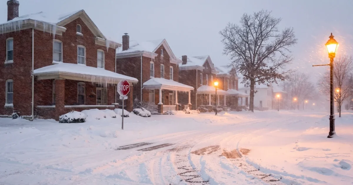
Blizzard warnings and winter storm alerts stretch across a broad swath of the country. The core impacts will focus on the Upper Midwest, the Great Lakes, and the interior Northeast. Snow rates will spike, visibility will vanish, and roads will glaze. Coastal New England faces a different risk, with damaging gusts and coastal flooding on the leading edge of the low. 🌬️
Blizzard conditions mean life threatening travel. Whiteouts, wind gusts over 50 mph, and drifting snow will strand vehicles and block roads. If you do not have to travel, do not.
Why this storm is a bomb cyclone
A sharp temperature contrast is fueling the engine. Arctic air is diving south. Milder, humid air is streaming north off the Atlantic and the Gulf. The jet stream is roaring overhead and venting the storm like a chimney. That combination, cold, warm, and fast upper winds, drives extreme pressure falls. The result is a tight spiral with wide reach. The wider the reach, the broader the impact zone.
This setup also explains the mixed hazards. The warm sector spawned severe thunderstorms and tornadoes in the Midwest earlier. Behind the front, cold air is rushing in, changing rain to snow and ice. The low will keep tapping ocean moisture as it lifts into New England, which boosts both snowfall inland and surge risk along the coast.
Regional impacts and timing
Upper Midwest and Great Lakes
Heavy snow bands will sweep east this evening into tonight. Expect rapid drops in visibility, sometimes to near zero. Wind gusts from 45 to 60 mph will create deep drifts. Lake effect will kick in after the main snow ends, adding another burst on the lee shores. Power outages are possible where heavy, wet snow loads trees and lines.
Interior Northeast and Appalachians
Snow arrives late tonight and intensifies on Thursday morning. The heaviest zone runs from western Pennsylvania through upstate New York and into interior New England. Snowfall rates could reach 1 to 2 inches per hour. Gusts of 50 to 65 mph will meet that snow, which will meet the definition of a blizzard in spots. Mountain passes will become treacherous.
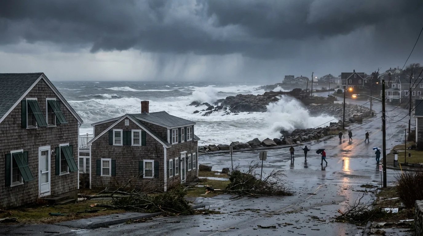
I 95 corridor and coastal New England
Along the coast, the air may stay warm enough for periods of rain or a brief mix. Do not relax. Gale to storm force gusts can bring tree damage and outages. Coastal flooding is likely at high tide, especially on north and east facing shores. As the low passes, colder air will sweep in fast, and flash freeze risks rise on wet roads.
Travel and safety guidance
Airlines are already adjusting schedules ahead of the worst conditions. If you have a flight, rebook early. On the roads, plan around the storm, not through it. If you lose power, use safe heating only. Never run a generator or grill indoors.
- Check your local forecast and alerts at weather.gov, then enable alerts on your phone
- Charge devices, gather flashlights, and prepare a three day supply of food and meds
- Avoid driving during peak snow and wind, and keep a winter kit in your car
- If flying, confirm status with your airline and monitor faa.gov for system delays
Pack a go bag with warm layers, batteries, water, snacks, and needed prescriptions. Keep it by the door in case you must move fast.
How this fits into a changing climate
Winter is still winter. Cold outbreaks and blockbuster snowstorms remain part of our climate. Yet the background has shifted. A warmer atmosphere holds more moisture. When the pattern supports snow, that extra moisture can supercharge snowfall and produce intense bands. Ocean heat also adds energy and moisture to coastal storms, which can deepen faster and push stronger onshore winds.
Scientists are studying how a warming Arctic may influence the jet stream. Some research links a wavier jet to more frequent sharp swings, from severe storms to sudden freezes. No single storm proves that link. But the pattern this week, strong temperature contrasts and deep moisture, fits what we expect in a warmer world, higher highs in moisture and stronger pressure gradients when cold and warm air collide.
Building resilience matters. Grid hardening, smarter tree trimming, better flood defenses, and weather ready homes all reduce risk. So does planning. Communities that prepare save lives and cut recovery time.
The bottom line
This bomb cyclone is not hype. It is a fast deepening storm with the power to shut down travel, snap power lines, and flood coasts. Make a plan today. Stay tuned to your local National Weather Service office at weather.gov and your city or county alert channels. Check on neighbors, especially those who may lose heat. We will keep tracking the pressure fall, the snow bands, and the wind field. I will update as the storm evolves and as the hazard shifts from blizzard to cleanup. Stay safe, stay warm, and do not take chances.


